 USA Site Plans

Lot Coverage vs Impervious Surface: What a Permit Site Plan Must Show
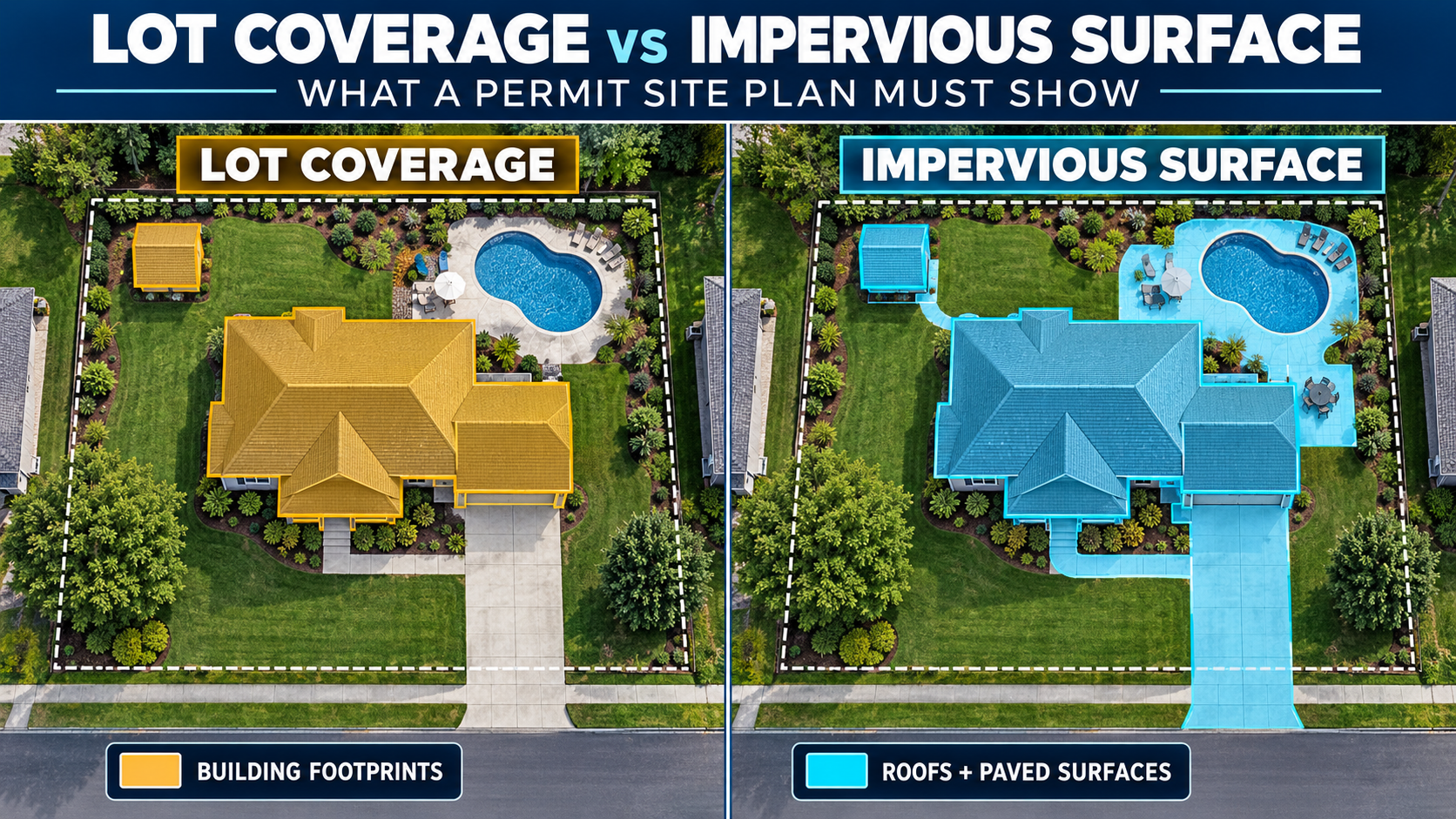
Lot coverage and impervious surface are two calculations that frequently appear on residential permit applications. Although the terms are sometimes used interchangeably, they can measure different parts of a developed property.
Lot coverage often concentrates on buildings and covered structures. Impervious-surface calculations generally include a broader range of areas that prevent or substantially reduce water from soaking into the soil, such as roofs, driveways, walkways and patios.
The exact definitions are established by the local jurisdiction. One municipality may count a paved driveway as lot coverage, while another places it only in the impervious-surface calculation. That is why a permit site plan must use the definitions and calculation methods found in the code governing the specific property.
Need Coverage Calculations on Your Site Plan?
USA Site Plans can prepare a scaled permit drawing showing existing and proposed structures, hard surfaces, property boundaries and coverage calculations.
The Basic Difference
| Question | Lot Coverage | Impervious Surface |
|---|---|---|
| What does it usually measure? | How much of the lot is occupied by buildings or other structures defined by the zoning code | How much of the site is covered by surfaces that limit water infiltration |
| Common examples | House, attached garage, covered porch, detached garage and shed | Roofs, driveway, walkway, patio, parking pad and other hard surfaces |
| Main regulatory purpose | Controls building intensity, open space and the physical mass of development | Controls runoff, drainage and the site’s ability to absorb rainfall |
| Is the definition universal? | No | No |
This is a general comparison rather than a universal legal definition. Always use the current zoning, land-development or stormwater code that applies to the property.
What Is Lot Coverage?
Lot coverage describes the portion of a parcel occupied by the features included in the jurisdiction’s coverage definition. In many codes, the calculation focuses primarily on building footprints and covered structures.
The City of Bellevue, Washington, provides a clear example. Its residential site-plan guidance defines lot coverage as the total building-footprint area divided by the applicable lot area. Bellevue requires the calculation to include primary structures, accessory structures and certain elevated decks. The city also excludes critical areas and associated primary setbacks from the lot-area denominator in some circumstances. See Bellevue’s current residential site-plan guidance.
A general lot-coverage formula is:
Counted building area ÷ applicable lot area × 100 = lot coverage percentage
However, every part of that formula depends on local definitions. The code determines:
- Which structures count toward coverage
- Where the footprint is measured
- Whether roof overhangs are included
- Whether elevated or covered decks count
- Whether pools, patios or driveways count
- Which portions of the parcel can be included in the lot-area denominator
Structures commonly reviewed for lot coverage
- The principal house
- Attached garages
- Detached garages
- Sheds and other accessory buildings
- Covered porches and patios
- Carports
- Gazebos and roofed outdoor structures
- Certain elevated decks
- Building additions
A structure does not necessarily have to contain conditioned living space to affect coverage. A roof supported by posts or columns may count even when the area beneath it is open.
What Is an Impervious Surface?
An impervious surface is generally a surface that prevents or substantially reduces rainfall from entering the soil. Traditional examples include rooftops, asphalt, concrete and compact paved areas.
The environmental reason for measuring these surfaces is straightforward. The U.S. Environmental Protection Agency explains that stormwater moving across asphalt and concrete can carry sediment, nutrients, pathogens, metals and other pollutants into waterways. The EPA also notes that absorbing and temporarily storing rainwater can reduce the volume entering stormwater systems. See the EPA’s explanation of the environmental effects of impervious surfaces.
A general impervious-surface formula is:
Counted impervious area ÷ applicable site area × 100 = impervious-surface percentage
Impervious area may include:
- House and accessory-building roofs
- Covered porches and patios
- Concrete or asphalt driveways
- Parking pads
- Walkways and steps
- Uncovered concrete patios
- Pool decks
- Equipment pads
- Compacted gravel areas in some jurisdictions
- Artificial turf or other low-infiltration systems in some jurisdictions
Materials marketed as permeable do not automatically receive an exemption. The code may require an approved installation method, underlying stone reservoir, engineering details or ongoing maintenance before granting a reduction or credit.
The EPA describes permeable pavement as a stormwater-control system that allows water to pass through the pavement surface into the ground below. That performance depends on the complete installed system—not simply on the appearance or product name of the surface. See the EPA’s permeable pavement guidance.
Why the Terms Can Be Confusing
Local codes do not use one national vocabulary. “Lot coverage,” “building coverage,” “site coverage,” “impervious coverage” and “impervious area” may describe overlapping or distinct calculations.
For example, Bellevue describes lot coverage primarily through building footprints. Arlington County, Virginia, defines lot coverage more broadly as the ratio of occupied areas—including buildings and driveways—to the total lot area. Review Arlington’s official lot-coverage guidance.
The difference between those two official approaches demonstrates why homeowners should not copy a calculation from another city, online example or neighboring property.
Before measuring anything, identify:
- The permit jurisdiction
- The property’s zoning district
- The exact term used by the local code
- The surfaces included in that definition
- The maximum percentage applicable to the lot
- The required calculation format
Lot Coverage Is Not Floor Area Ratio
Lot coverage should also be distinguished from floor area ratio, commonly abbreviated as FAR.
Coverage normally evaluates the horizontal area occupied on the ground. FAR compares the building’s counted floor area—potentially including multiple levels—with the lot area.
Consider a two-story house. Its coverage calculation may be based largely on the building footprint, while an FAR calculation can include eligible floor area from both stories. The exact treatment of basements, garages, attics and other spaces depends on the local code.
A permit application may require coverage, FAR or both. Do not substitute one calculation for the other.
What Must the Permit Site Plan Show?
A strong permit site plan separates existing conditions from proposed work and gives the reviewer enough information to reproduce the calculations.
Johnston County, North Carolina, requires residential site plans to clearly delineate existing and proposed impervious surfaces and list them in square feet. It also requires the established impervious limit to be shown. See the county’s current residential site-plan requirements.
1. Complete property boundary
Show the lot lines and dimensions using the best available deed, plat or survey information. Coverage calculations cannot be verified without the applicable lot area.
Do not assume that a GIS parcel overlay is sufficiently accurate for a permit drawing. A licensed survey may be necessary when the boundary cannot be reliably established or the authority requires a certified document.
2. Existing building footprints
Identify every existing building and covered structure, including the house, garage, carport, shed and covered outdoor areas. Provide footprint dimensions or calculated areas.
A common error is showing the proposed addition or shed while omitting an older accessory building. Reviewers generally need the total post-project condition.
3. Proposed construction
Use different linework, shading or labels to distinguish proposed work. The plan should show the dimensions and area of each proposed feature.
Examples include:
- A home addition
- A new detached garage
- A shed or carport
- A covered porch
- A pool and pool deck
- A driveway extension
- A new patio or walkway
4. Existing impervious surfaces
Show all existing hard or low-infiltration areas included by the local definition. Do not limit the drawing to roofs if the jurisdiction also counts driveways, sidewalks, patios or gravel.
The City of Bradenton, Florida, identifies additions, driveways, sidewalks, pool decks and slabs as examples of projects that may increase impervious surface area. The city maintains separate forms for impervious coverage and lot coverage, further illustrating that the two calculations can serve different regulatory purposes. See Bradenton’s building forms and application guidance.
5. Demolition or surfaces being removed
If part of the project removes an existing shed, patio, walkway or driveway, show that area separately. The reviewer should be able to see:
- Existing area
- Area being removed
- New area being added
- Final total after construction
Do not simply subtract the demolished area without identifying it on the drawing. Clear demolition linework helps the reviewer understand why the existing and proposed totals differ.
6. A coverage table
Include a table that lists each counted feature individually. A useful format is:
| Surface or Structure | Existing Area | Removed Area | Proposed Area | Final Area |
|---|---|---|---|---|
| House footprint | Enter area | Enter area | Enter area | Enter total |
| Accessory structures | Enter area | Enter area | Enter area | Enter total |
| Driveways and parking | Enter area | Enter area | Enter area | Enter total |
| Patios and walkways | Enter area | Enter area | Enter area | Enter total |
The final plan should use the jurisdiction’s actual categories rather than treating this example as a universal form.
7. Applicable percentage and allowable area
Show the maximum coverage permitted for the parcel, the proposed final percentage and the remaining area, if requested.
If the lot is already close to its maximum, small improvements can matter. A covered entry, enlarged driveway, equipment pad or walkway may use some or all of the remaining allowance.
8. Drainage information
Some jurisdictions require only the coverage calculation. Others may request grades, drainage arrows, downspout discharge locations, stormwater facilities or erosion-control measures.
The purpose is to show how additional runoff will be handled without creating a problem for adjacent properties, public systems or environmentally sensitive areas.
How to Calculate the Areas
Rectangular areas
Multiply the measured length by the measured width:
Length × width = area
Irregular areas
Divide an irregular surface into smaller rectangles, triangles or other manageable shapes. Calculate each section and add the results.
Circular areas
For a circular area, use:
π × radius² = area
Roof overhangs
Do not automatically use exterior wall dimensions. Some codes calculate the building footprint using roof edges or include overhangs beyond a specified projection. Others exclude ordinary eaves. Follow the local definition and measurement instructions.
Sloped surfaces
Coverage is generally represented as a horizontal plan-view area rather than the sloped surface area of a roof or driveway. Confirm the required method if the site has steep grades or unusual construction.
What About Gravel, Pavers and Artificial Turf?
These materials create frequent permit questions because their treatment varies considerably.
Gravel
A loose stone area may allow some infiltration, but repeated traffic can compact the soil beneath it. Some jurisdictions therefore count gravel driveways and parking areas as fully or partly impervious.
Permeable pavers
Permeable pavers may receive special treatment when installed as part of an approved infiltration system. Ordinary pavers over a compacted base may still be treated as impervious.
Artificial turf
Artificial turf may or may not qualify as permeable. The determination can depend on the backing, base material, drainage design and local definition.
Wood decks
An uncovered deck with gaps between its boards may be excluded, counted fully or assigned partial coverage. The treatment may also depend on the surface below the deck and its height above grade.
Label the material and construction method rather than describing every surface simply as “patio” or “landscaping.”
Can Rain Gardens or Permeable Pavement Increase the Allowance?
Some stormwater programs offer credits, alternative compliance methods or different treatment for approved green infrastructure. This is not automatic.
The EPA identifies rain gardens, bioswales, green roofs and permeable pavements as methods of capturing, filtering or infiltrating stormwater. These features can reduce runoff, but permit credit depends on local design standards and approval. Review the EPA’s overview of green-infrastructure practices.
Do not reduce the calculated impervious area unless the local code or reviewer authorizes that treatment.
Common Coverage Calculation Mistakes
- Using “lot coverage” and “impervious surface” as interchangeable terms
- Following definitions from a different city or county
- Omitting sheds, carports or covered porches
- Showing the proposed project without the existing development
- Leaving driveways, walkways or patios out of the impervious calculation
- Assuming gravel is automatically permeable
- Using interior room dimensions for exterior building coverage
- Failing to show areas being demolished
- Using the wrong lot-area denominator
- Rounding individual areas so aggressively that the total becomes inaccurate
- Providing only a final percentage without showing how it was calculated
Our site plan checklist for permit approval can help you identify other information that may be required before submission.
What If the Property Is Already Over the Limit?
An existing property may exceed the current limit because it was developed under an earlier code, received a variance or contains unpermitted improvements. Do not assume that additional coverage will be approved simply because the existing condition has been present for many years.
The planning department may require you to:
- Document the lawful existing condition
- Remove or reduce another covered area
- Revise the proposed project
- Provide stormwater mitigation
- Apply for an administrative adjustment or variance
- Resolve previously unpermitted work
Provide an accurate existing-and-proposed plan and ask the department which process applies before beginning construction.
Is a Site Plan the Same as a Survey?
No. A permit site plan organizes property and project information for review. A boundary survey is prepared by a licensed land surveyor and professionally establishes or documents property boundaries.
USA Site Plans provides unsigned drafting services. Its plans are not represented as signed or sealed surveys, engineering plans or architectural drawings.
A licensed surveyor or other design professional may be required when:
- The authority requires a signed or sealed plan
- The property boundaries cannot be reliably located
- The project is close to a setback or coverage limit
- The lot contains difficult topography or drainage conditions
- Stormwater calculations require engineering
- Recorded easements or title issues require professional interpretation
See our explanation of the definition and purpose of a site plan for more information.
Information to Gather Before Ordering a Site Plan
- The property address and parcel number
- A deed, plat or previous survey
- The applicable zoning designation
- The local coverage or impervious-area worksheet
- Exterior dimensions of all buildings
- Dimensions and materials of driveways, patios and walkways
- Dimensions of proposed construction
- Details of surfaces that will be removed
- Photos of the property
- Any permit checklist or correction notice
Frequently Asked Questions
Does a driveway count as lot coverage?
It depends on the local definition. Some jurisdictions include driveways in lot coverage, while others include them only in impervious-surface calculations.
Does a pool count as impervious surface?
Pool decks and equipment pads are commonly reviewed, but the treatment of the water surface varies. Check the applicable ordinance and worksheet.
Does a shed count toward both calculations?
Often, yes. A shed is a building footprint and its roof also sheds water. However, exemptions or thresholds may apply under the local code.
Is grass considered impervious?
Ordinary vegetated soil is generally considered pervious, but compacted soils and specially constructed surfaces may receive different treatment under a particular stormwater ordinance.
Can I calculate coverage from an aerial photograph?
An aerial image can help with preliminary planning, but perspective, image resolution and boundary alignment can produce inaccurate areas. Permit calculations should be based on reliable dimensions and applicable property records.
Do I need coverage calculations for a small residential project?
Possibly. A small shed, patio or driveway extension can affect an already developed lot. Follow the permit checklist for the specific jurisdiction and project.
Show Both Calculations Clearly
The safest permit plan does not force the reviewer to guess which surfaces were counted. It identifies every existing, removed and proposed area, separates building coverage from impervious surface and shows the calculations using the jurisdiction’s definitions.
This approach helps identify coverage problems before construction and can reduce questions during permit review.
Get a Clear Permit Site Plan
Send us your property information, project dimensions and local permit requirements. We can prepare a professional site plan showing the coverage information required for review.
Definitions, exemptions and maximum coverage limits vary by jurisdiction and property. Confirm current requirements with the planning, zoning, building or stormwater department responsible for your permit before construction.