 USA Site Plans

“`html
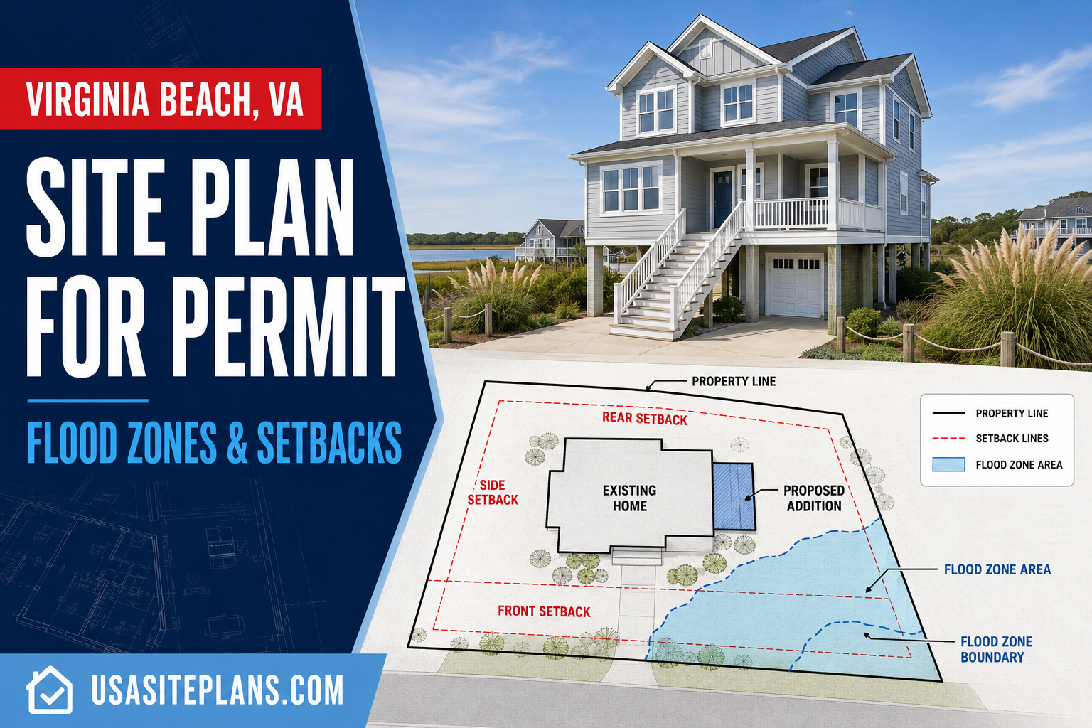
Planning a garage, shed, home addition, deck or other residential project in Virginia Beach? Your permit application may need a site plan showing the proposed construction, property lines, required setbacks and applicable flood-zone information.
A clear site plan for a permit in Virginia Beach, VA helps reviewers understand where the project will be built and whether its location could be affected by zoning, flooding, drainage or environmental restrictions.
Need a Virginia Beach Site Plan?
Send us your property documents, project dimensions and a simple sketch. We can prepare a clear residential site plan for your permit application.
Why Might Virginia Beach Require a Site Plan?
A site plan gives permit reviewers an overhead view of the complete property. It identifies the existing buildings, proposed construction and important restrictions that affect where the project can be placed.
The City of Virginia Beach requires building permits for many new structures and alterations. Examples include:
- Attached and detached garages
- Carports
- Room additions
- Screened porches
- Large sheds and storage buildings
- Decks and elevated platforms
- New homes
- Structural alterations
A permit application may require a site plan or physical survey showing the proposed work. Other construction drawings can also be required.
What Should the Site Plan Show?
The required information depends on the project and property. A useful Virginia Beach residential site plan will commonly include the following details.
Property Lines
Show the complete lot boundary and available dimensions. The property lines should be clearly different from setback lines, flood-zone boundaries and easements.
Existing Buildings
Identify the existing home, garage, shed, deck, porch and other significant structures.
Proposed Construction
Clearly label and dimension the proposed addition or detached structure. Show the distances between the project and the relevant property lines.
Front, Side and Rear Setbacks
Show the required yard setbacks and the actual distance from the proposed construction to each affected property line.
Flood-Zone Boundary
If an official flood-zone boundary crosses the property, show its approximate location using reliable mapping or survey information. Label the mapped area without obscuring the buildings or setback dimensions.
Streets and Driveways
Identify adjacent streets, the driveway and other access areas. These features are especially important for garages, carports and front-yard projects.
Easements and Drainage Features
Show known utility, access and drainage easements. Include visible ditches, swales or drainage facilities when they affect the project.
Scale and North Arrow
Use an appropriate drawing scale and include a north arrow so the property can be oriented correctly.
Understanding Virginia Beach Flood Zones
Virginia Beach contains coastal, tidal and low-lying inland areas. Flood risk can vary considerably from one property to another and sometimes across a single lot.
Flood maps divide land into different risk areas. Properties within a Special Flood Hazard Area can be subject to additional construction, insurance and elevation requirements.
A mapped flood zone can affect:
- Where a structure can be built
- The required elevation of occupied floors
- Foundation and flood-opening requirements
- Placement of mechanical and electrical equipment
- Use of enclosed areas below the required elevation
- Flood-resistant materials
- The need for an elevation certificate
- Flood-insurance requirements
The City provides floodplain information and mapping resources through its Floodplain Management office.
What Is a Base Flood Elevation?
The base flood elevation is the estimated elevation that floodwater may reach during the flood event used for regulatory mapping and building standards.
If the property is in a regulated flood area, the City may compare the proposed building elevation with the applicable base flood elevation. Additional freeboard or other local requirements may apply.
A standard site plan can show the mapped flood-zone boundary when reliable information is available. It does not determine or certify the building elevation.
What Is an Elevation Certificate?
An elevation certificate records important building and ground elevations. It is normally prepared by a qualified licensed professional using field measurements.
Virginia Beach explains that elevation certificates can be used to compare a home’s lowest-floor elevation with the expected floodwater elevation. They may also be used for flood-insurance rating and development review.
An elevation certificate is different from a standard site plan:
- Site plan: Shows where the buildings and project are located on the lot.
- Elevation certificate: Certifies measured elevations in relation to flood requirements.
If the permit office requests certified elevation information, hire a Virginia-licensed surveyor or other qualified professional.
Important: Flood maps and requirements can change. Confirm the current designation with Virginia Beach Floodplain Management before designing or building the project.
How Setbacks Work in Virginia Beach
A setback is the minimum required distance between a structure and a property line, street or another regulated feature.
Virginia Beach assigns a zoning district to nearly every privately owned property. The City’s Zoning Ordinance establishes allowable uses and minimum yard requirements for each district.
The applicable setback can depend on:
- The zoning district
- The proposed use
- Whether the structure is attached or detached
- The structure’s size and height
- Whether the lot is on a corner
- Whether the project is in a special zoning area
- Previously approved variances or conditions
- Environmental buffers or easements
Do not assume that a neighboring garage or shed establishes the setback for your property. It may have been constructed under different regulations or approved through a variance.
Setback Inspections
The City’s residential permit guidance lists setback or footing inspections for several types of construction, including new buildings, additions and certain garages or sheds.
This means the project location may be checked before the foundation is completed. If the structure is too close to a property line, correcting the problem after work begins can be expensive.
When construction is close to the required setback, the City may request a surveyor’s certification or other reliable evidence of the foundation location.
Flood Zones and Setbacks Are Separate Requirements
A proposed structure can meet its zoning setbacks but still have floodplain problems. It can also be outside a high-risk flood zone but fail the required setback.
The site plan should therefore show both:
- The building-placement limits created by zoning setbacks
- The mapped flood-zone information affecting the property
Neither requirement replaces the other. Additional drainage, environmental or easement restrictions may also apply.
Chesapeake Bay Preservation Areas
Some Virginia Beach properties are located within a Chesapeake Bay Preservation Area. These areas protect water quality and can include regulated buffers near waterways, wetlands and other sensitive features.
A flood zone and a Chesapeake Bay Preservation Area are not the same thing. A property can be affected by one, both or neither.
The City’s Development Services Center reviews certain single-family site plans within Resource Protection Areas. Work in these areas may require:
- A preliminary project review
- A plan of development
- Buffer identification
- Limits on land disturbance
- Tree-preservation or mitigation information
- Additional drainage or environmental review
Check the City’s environmental maps before placing an addition, shed, deck or other improvement near a waterway or wet area.
Wetlands, Southern Watershed and Waterfront Projects
Waterfront and wetland-related construction can require additional permits. Structures in the Chesapeake Bay Preservation Area or Southern Watershed Area may also require review even when a similar project elsewhere might qualify for an exemption.
Examples of work that may need specialized review include:
- Piers and docks
- Bulkheads and shoreline stabilization
- Boat lifts
- Riprap
- Work near tidal wetlands
- Construction affecting a protected buffer
A standard residential site plan does not replace wetland delineation, shoreline engineering or environmental approvals.
Property Lines Must Be Reliable
Setback dimensions depend on the correct property boundary. Do not assume that a fence, seawall, ditch, curb or landscaping edge is the legal lot line.
Useful sources include:
- A recent physical survey
- A recorded subdivision plat
- A previously approved site plan
- Title and deed documents
- A survey prepared by a Virginia-licensed surveyor
Online mapping is useful for preliminary planning, but it does not legally establish property boundaries. Obtain a survey when the project is close to a setback or easement.
When Is a More Detailed Plan Required?
A basic unsigned site plan may work for many straightforward residential projects. More detailed plans may be necessary when the property:
- Is inside a Special Flood Hazard Area
- Requires certified elevations
- Is within a Chesapeake Bay Resource Protection Area
- Contains wetlands
- Is near a shoreline or drainage channel
- Requires significant grading or fill
- Contains uncertain property boundaries
- Is affected by drainage or environmental easements
The City may require drawings, reports or certifications prepared by a licensed surveyor, engineer, architect or environmental professional.
Information to Collect Before Ordering
Please gather:
- The complete Virginia Beach property address
- A physical survey, recorded plat or previous site plan
- The dimensions of the proposed structure
- The preferred project location
- Distances to nearby property lines
- The property’s zoning district and required setbacks
- Current flood-zone information
- Known drainage and utility easements
- Any available elevation certificate
- Property and project-area photographs
- A simple project sketch
- Any City checklist or correction notice
Your sketch can be hand drawn. Clearly identify the street, existing home, proposed project and any mapped flood-zone boundary that crosses the property.
How USA Site Plans Can Help
USA Site Plans prepares clear residential site plans using available property records, customer measurements and project information.
Your Virginia Beach plan can show:
- The property boundary and lot dimensions
- The existing home and accessory structures
- The proposed addition or detached building
- Front, side and rear setbacks
- Available flood-zone boundaries
- Known easements and drainage features
- Adjacent streets and driveways
- Labels, scale and north arrow
Our standard drafting service offers a 24-hour turnaround after complete information has been received. If the permit reviewer requests a correction to information shown on the plan, send us the written comments so we can review the requested change.
Please note: USA Site Plans provides unsigned drafting plans. We do not perform boundary surveying, elevation certification, floodplain engineering or wetland delineation. Some projects require documents stamped by a Virginia-licensed professional.
Frequently Asked Questions
Does every Virginia Beach permit need flood-zone information?
No. Requirements depend on the property and project. Flood-zone and elevation information becomes particularly important when construction is within or near a regulated flood hazard area.
Can USA Site Plans prepare an elevation certificate?
No. An elevation certificate requires field measurements and professional certification. We can show elevation information supplied by a qualified source.
Are setbacks the same throughout Virginia Beach?
No. Minimum yards depend on zoning, the project type and special property conditions. Confirm the requirements with Zoning Administration.
Can a proposed structure cross a flood-zone boundary?
Possibly, but additional construction and elevation requirements may apply. Confirm the design with Floodplain Management before finalizing the location.
Does being outside a high-risk flood zone mean there is no flood risk?
No. Flooding can occur outside mapped high-risk areas. Local drainage, heavy rainfall, tidal conditions and changing maps can still affect the property.
Can an online parcel map replace a physical survey?
No. Online mapping is useful for general research but does not legally establish property boundaries or certified elevations.
Order Your Virginia Beach Site Plan
A clear site plan helps permit reviewers understand how the proposed project relates to property lines, required setbacks, flood-zone boundaries and existing development.
Send us your property documents, measurements and project sketch. We will convert the information into a professional drawing suitable for many straightforward residential permit applications.
Official Virginia Beach Resources
- Virginia Beach Residential Building Permits
- Virginia Beach Floodplain Management
- Virginia Beach Zoning Information
- Virginia Beach Site Plan Requirements
- Chesapeake Bay Preservation Area Information
“`
**Yoast SEO**
* **Focus keyphrase:** site plan for permit in Virginia Beach VA
* **SEO title:** Virginia Beach Site Plan: Flood Zones & Setbacks
* **Slug:** `site-plan-permit-virginia-beach-va-flood-zones-setbacks`
* **Meta description:** Need a site plan for a permit in Virginia Beach, VA? Learn how flood zones, elevation requirements and setbacks can affect your project.
* **Related keyphrases:** Virginia Beach permit site plan, Virginia Beach plot plan, Virginia Beach flood-zone plan, Virginia Beach setback plan, residential site plan Virginia Beach
* **Social title:** Site Plan for Permit in Virginia Beach, VA
* **Social description:** Learn what a Virginia Beach permit site plan should show, including property lines, setbacks, flood-zone boundaries and proposed construction.
* **Image alt text:** Site plan for permit in Virginia Beach Virginia showing flood-zone boundaries and building setbacks
* **Image title:** Virginia Beach Site Plan for Permit – Flood Zones and Setbacks
* **Image caption:** A Virginia Beach permit site plan showing the property boundary, proposed addition, required setbacks and mapped flood-zone area.